Learn about the software helping wetland scientists tighten project timelines by boosting efficiency in the field and back at the office.
This topic was covered in the 22nd episode of Ecobot’s webinar series, Convergence of Wetland Science and Technology. View recorded episodes here.
Topics
- Efficient WOTUS data collection
- Geospatial data: field to office and office to field
- Real-time data exchange and team management
- Subcontractor and seasonal access
Moderator Jeremy Schewe, PWS, Chief Scientist, Ecobot
Presenters & Panelists
Corinna Photos, PWS, Senior Project Manager, Spirit Environmental
Jodie Burns, PWS, Principal & Senior Scientist, Cattails Environmental
Sarah Lewis, Project Biologist, Lord and Winter
Kristin Wing, Environmental Analyst, Beam, Longest and Neff
The Wetland Science Digital Ecosystem “I want to launch this with a reminder,” says Jeremy Schewe, PWS, Chief Scientist at Ecobot. “It’s really important that we are ascending biological data into the digital ecosystem. Here in the 21st century, where most things are in some way data-driven, data is being utilized to understand better economics. It’s being utilized to better understand how policy can be shaped. And if we’re not contributing biological data, natural resource data, to help improve our understanding on a macro-scale on the landscape level, then we’re doing our own future and the generations that are going to come after us a disservice.”
The digital ecosystem Schewe speaks of in respect to wetland science is the combination of GPS receivers, GIS software, field applications, satellites, drones, and more, which enable better understanding, interpretation, and recording of biological information, which can then be shared with laypeople, regulators, and policymakers.
The Essentials Schewe, along with colleagues Corinna Photos, PWS, Senior Project Manager, Spirit Environmental; Jodie Burns, PWS, Principal & Senior Scientist, Cattails Environmental; Sarah Lewis, Project Biologist, Lord and Winter; and Kristin Wing, Environmental Analyst, Beam, Longest and Neff, each share a handful of essential tools that they and their teams bring into the field. These are:
Hardware:
- iPhone or iPad for running mobile field data collection platforms
- An external power bank for backup battery power
- External GNSS device, such as a Trimble device, Eos Arrow, Juniper Geode, or SXblue for highly accurate location data
Software:
With this combination of technology, the teams are able to work efficiently, especially across large project areas. With Field Maps, teams can bring along the detailed basemap they or their GIS team built in advance of fieldwork, and update the map once they’re on the ground. Multiple teammates can use the same basemap, such as in the case of Wing’s team, who tends to use the same large basemap all season long.
Ecobot enables efficient workflow-based data collection with or without a cellular connection. Project managers and coworkers back at the office can access the data and begin QA as soon as the project is synced to the cloud. Teams have seen the benefits from having their data centralized and easily accessible: Photos’ team, for example, recently worked on a project that was across the street from a previous site. With the prior project at their fingertips, her team was able to easily check what features and conditions they were likely to see. Automated calculations and built-in reference tools bolster efficiency and accuracy during data collection, and data is automatically transferred to the U.S. Army Corps of Engineers (USACE) form with the click of a button.
How does Ecobot stack up to the automated data forms recently released by USACE? Burns has personally experimented with the automated data sheets, and is also a long-time Ecobot user. “It does [calculations] similar to what Ecobot does, but I tried to get the automated data sheets to work in the field with my iPad setup, and the Excel version that is iPad-friendly is not robust enough. … When I use those, when I come back to the office, I still have half a foot in the paper world.”
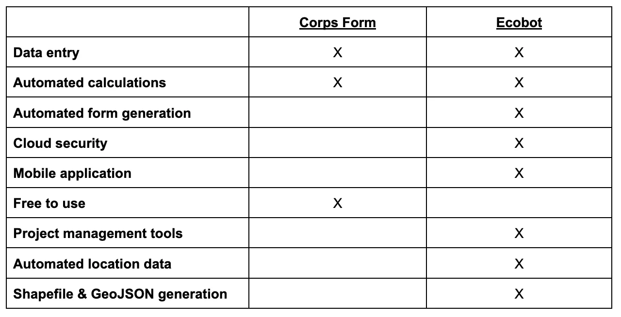
The critical difference: Ecobot is a workflow, not a data entry application. Built from inside the industry to be intuitive to wetlands scientists, the platform facilitates collaboration and streamlines the workflow between team members in the field and at the office. In addition to the features that simplify data collection itself, Ecobot’s web dashboard enables PMs and teammates back at the office to access and QA project files remotely as soon as they hit the cloud. Ecobot generates completed USACE forms and CSVs for each project. It also creates Shapefiles and GeoJSONs, which can be easily transferred to Field Maps or ArcGIS. In other words, it fits in seamlessly with the other pieces of the workflow, making report generation and submission easier than ever.
Tighter Project Timelines with Ecobot Ultimately, clients of Ecobot customers see faster project turnarounds, thanks to the boosts to efficiency throughout the workflow.
“I’ve probably done, on my most efficient day in the field, 20-25 points or so…” Lewis says. “[We had] pre-mapped areas, going to check out a very large site. But that was Ecobot. We utilized Ecobot on that project.” In particular, says Lewis, the vegetation calculations and built-in QC were major efficiency boosters on that project.
Lewis has also saved time in the field using the cloning tool, which enables her to copy a sampling point if there is significant overlap in the features in multiple sampling points. She then manually changes, deletes, and adds data where the new point differs. As an example, she says, “If you’re in a very similar hardwood forest, where it’s pretty uniform throughout, I have definitely used clone…Then I’ll update my point…change the percentage of the vegetation. Most of the efficient days I have, I was cloning a good bit of my sampling points.”

